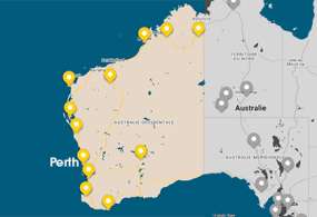
Découvrir le parc national de Cape Range
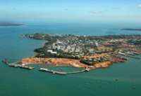
Cape Range National Park à Ningaloo Reef
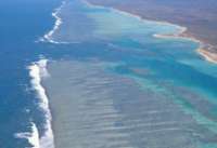
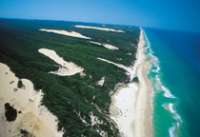
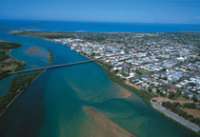
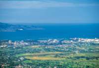
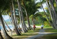
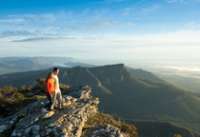
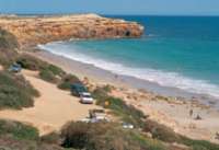
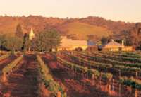
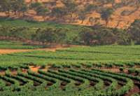
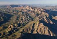
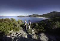
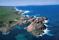
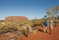
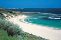
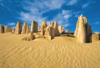
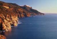
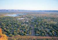
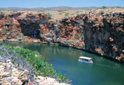
L’incontournable parc national de Cape Range est situé sur la côte Ouest à Ningaloo Reef, à seulement 40 km d’Exmouth et 200 km de Coral Bay. La côte est de Cape Range National park, accessible par des pistes 4x4, offre des paysages spectaculaires de gorges rocheuses sculptées par d’anciennes rivières, qui s’élèvent à 315 mètres de haut. Sur la côte ouest de Cape Range, se trouvent les plages de Ningaloo Reef, Yardie Gorge, Mandu Gorge et le centre des visiteurs Milyering, accessible par une route goudronnée par le nord ou par une piste 4X4 depuis le sud.
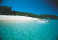
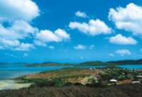
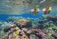
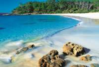
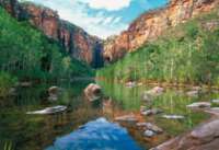
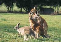
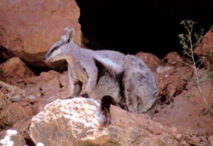
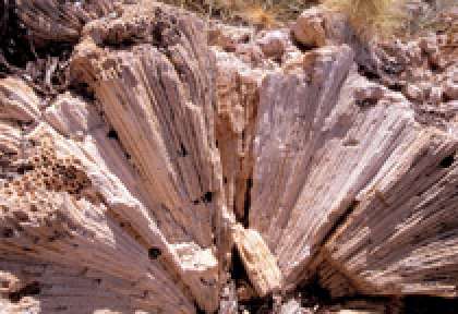
Le parc national de Cape Range est connu pour ses magnifiques contrastes entre ses impressionnantes falaises de calcaire aux couleurs ocres, ses eaux claires, ses récifs coralliens et ses plages de sable fin. Le site de Yardie Creek est unique pour sa colonie de wallabies des rochers.
Mantarays Ningaloo Beach Resort

À 5 km d'Exmouth, cet hôtel moderne est situé sur Sunrise Beach, près de superbes plages de sable fin, et fait partie du plan de développement opéré sur la marina. Le Mantarays Ningaloo Beach Resort est le point de départ idéal pour découvrir les trésors naturels de North West Cape, dont Ningaloo Reef.

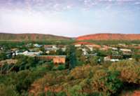
A 1 264 km au nord-ouest de Perth, cet hôtel est situé au coeur de la ville d'Exmouth et permet d'accéder facilement aux trésors naturels de North West Cape. Depuis le Potshot Hotel, vous pourrez découvrir le superbe parc national de Cape Range, ainsi que le somptueux récif ...

Ce beau « resort » est idéalement situé dans la ville de Coral Bay, à environ 50 mètres des superbes plages de sable fin et à moins de 100 mètres du récif corallien. Depuis le Ningaloo Reef Resort, vous pourrez explorer les profondeurs du récif ...

À mi-chemin entre Coral Bay et Exmouth, Bullara Station Stay est une ferme d’élevage en activité offrant une halte chaleureuse sur la Côte de Corail. Camping ou cottage tout confort, à chacun son style pour profiter de l’ambiance conviviale du campement. Depuis la ferme, l’accès au Parc national de Cape Range et à ...

Ces tentes de luxe sont situées à 70 km d'Exmouth, soit environ une heure en voiture, et sont nichées parmi les dunes de sable à 50 mètres d'une superbe plage de sable blanc. Sal Salis Ningaloo Reef est au coeur du parc national de Cape Range, et vous offre un séjour unique et ...

Surplombant les eaux turquoise du parc marin de Ningaloo Reef, le Ningaloo Coral Bayview bénéficie d'une situation idéale à deux pas de la plage de Coral Bay. Ce camping familial propose une large gamme d’hébergements pour tous les budgets, ainsi que des emplacements de camping. Que vous soyez en famille, en couple, en ...
Simpsons Gap

Dampier Archipelago

Leeman

Mt Whaleback

Mines de Newman
Waddy Point

Rainbow Beach

Tin Can Bay

Lake McKenzie

Wungul Sandblow

Emerald Creek Falls

Eurimbula NP

Minerva Hills Np

Keswick Island

Springsure

Capella

Cania Gorge NP

Capricorn Caves

Bowen

Nebo

Brampton Island

Eungella NP


Cette île de corail est située juste sur le récif au large du Queensland, à environ 72 km au nord-est de Gladstone, soit à 2 heures de bateau ou à 30 minutes d’hélicoptère. Heron Island est une petite île recouverte d’une forêt dense, et ...

Située à 30 minutes de vol de Bundaberg et 1 h 20 de Brisbane sur la partie Sud de la Grande Barrière de Corail, Lady Elliot Island est une île corallienne réputée pour la richesse de ses récifs et la présence des majestueuses raies manta et tortues. Lady Elliot Island Eco Resort propose des hébergements les pieds dans ...
Mon Repos

Agnes Water

Town of 1770

Gladstone

Rockampton

Yeppoon

Blackdown Tableland NP

Hamilton Island

Heart Reef

Langford Island

Cape Hillsborough NP
Wallaman Falls

Hinchinbrook Island

Norman River

Burketown

Cobbold Gorge

Forsaith
Paluma Range

Little Crystal creek
Paluma Range NP

Crystal creek
Girringun NP

South Molle Island

Hells Gate

Dill Doll Rocks
Charters Towers

The Burdekin


Hidden Valley cabins & Platypus safari, est un éco-resort primé, et aussi le premier resort en Australie à s'engager pour le zéro carbone ayant recourt à l'énergie solaire à 100%. Le resort est située à 1h30 au nord-ouest de Townsville, ...
Lakefield NP

Lawn Hill NP

Constance Range
Lawn HIll Gorge

Lockhart

Horn Island

Eliott Falls

Cap York


Annan Gorge

Split Rock - Laura

Northernmost Point

Low Island

Kuranda

Green Island

Bloomfield Falls

Daintree National Park

Cape Bedford

Wooroonooran NP

Rafting - Tully River

Dunk Island

Bloomfield Track

Mossman Gorge

Cooktown

Cape Tribulation

Undara Volcanic NP

Atherton Tableland

Zillie Falls
Survol de la Grande Barriere

Agincourt Reef

Wolfe Creek Meteorite

Scarborough


Freemantle

Lake Ballard

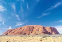
Kata Tjuta - Monts Olga

Yourambulla

The twelve apostles

Coorong

Naaracoorte

Robe

Coonawarra

Mt Gambier


Great Otway National Park

Torquay

La plage de Bells beach à Torquay
Warrnambool

Port Fairy

Seals Bay

Ramarkable Rocks

Kelly Hill

Little Sahara

Penneshaw

Lac Eyre

Leafy Seadragon

Snelling beach

Adelaide Hills

Murray River

Wilpena Pound

Leigh Creek

Arkaroola

William Creek

The Breakaways

Painted Desert

Simpson Desert

Strzelecki Track

Oodnadatta

Lake Gairdner

The Great Australian Bight

La Grande Baie australienne
Gawler Ranges

Ceduna

Hopkins Island

Nager avec les Lions de mer à Hopkins Island
Nullarbour Highway

Innes National Park

Mt Baw Baw

Ninety Mile Beach

Lakes Entrance

Croajingolong National Park

Walhalla

Yarra Valley

Dandenong Ranges

Lake Daylesford

Shepherds

Ferme de Lavande à Shepherds
Goldfields

Ballarat

Bendigo

Albury

Lake Mulwala

Murray River

Alpine National Park

Mt Hotham

Lake Jindabyne

Beechworth

Kosciusco - Alpine Way

Eden

Cape Conran

Pambulla


Tomakin

La Sapphire coast

Kangaroo Valley

Hunter Valley

Port Stephens

Grand Pacific Drive

Dorrigo National Park

Coffs Harbour

Wollemi National Park

Myall Lakes National Park

Mutawintji National Park

Menindee Lakes

Mungo National Park

Silverton

Arltunga Tourist Drive

Litchfield National Park

Mary River National Park

Tiwi Islands

Mataranka

Nourlangie Rock

Ubirr Rock

Gunlom Falls

Barramundie Gorge

Twin Falls

Jim Jim Falls

Yellow Waters

17 Mile Falls - Tjabula Trail

Douglas River - Daly River

Timber Creek

Keep River National Park

Injalak Hill - Gunbalanya

Cobourg Peninsula

Black Point
Garig Gunak Barlu National Park

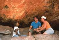
Découvrez, en 3 jours, des lieux hors des sentiers battus, où la présence aborigène remonte à plus de 50 000 ans, lieu où vous échappez aux pressions de la civilisation.
Fogg Dam

Devil's Marbles

Palm Valley - Finke gorge National Park

Rainbow Valley

West MacDonnel Ranges

East MacDonnel Ranges

Barrière à Dingo

Ormiston Gorge

Trephina Gorge

Glenn Helen Gorge

Mt Connor


Port Denison

The Stromatolites - Hamelin pool

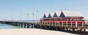
Busselton Jetty

Whale Watching à Busselton

Forêt de karris - Boranup forest

Sugarloaf Rock

Bibbulmun Track - Albany

La côte d'Albany

Fitzgerald River National Park

La plage de Quoins Head
Leeuwing Naturalist National Park

La plage de Redgate Beach
D'Entrecasteaux National Park

La plage de Mandalay
Valley of the Giants

Tree top Walk
Cape Le Grand National Park

William Bay National Park

Kookynie

Laverton

Leonora

Kalgoorlie

Goldfields

Cape Le Grand National Park

Thistle cove
Conto Springs Beach

Striling National Park

Bluff Knoll Walk
Mount Ragged - Cap Arid National Park

Mount Barren - Fitzgerald River National Park

Lake Cave - Mammoth Cave

Dunes - Fitzgerald River National Park

Greenbushes

Willian Bay National Park

Fitzgerald River National Park

Bunbury

Cape Leeuwin

Mount Barker

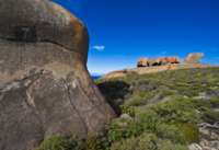
Cape Range National Park

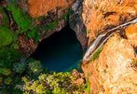
Yardie Creek
Cape Range National Park

Shothole Canyon
Muiron Islands

Shell Beach - Shark Bay

François Peron National Park - Shark Bay

Bottle Bay
François Peron National Park - Shark Bay

Big Lagoon
Kalbarri National Park

Kalbarri National Park

Eagle gorge coastline
Kalbarri National Park

Hawk's Head look out
Kalbarri National Park

Look Out Ross Graham
Hutt River Province

Lancelin

Port Denison

Dunes de Lancelin

Jurien Bay Marine Park

Yanchep National Park

Rottnest Island

Swan Valley

Coolie

Waves Rock - Hyden

Bingara

Cowra

Port Macquarie

Crowdy Bay National Park

Diamond Head
Bourke

North Bourke Bridge 1880.
Murgon

Bunya Mountains NP

South Burnett

Maryborough

Caloundra

Mapleton Forest

Montville

Maleny

Glass House Mountains

Hervey Bay

Ferme de chameaux

Springbrook NP

Lamington NP

Stradbroke Island

Stradbroke Island

Moreton Island

Moreton Island

Paturages - Flinders island

The docks - Flinders Island

Trouser Point

Mt Lot

Stanley

Queenstown

Derwent River

Strahan

Lake St clair

Overland Track

Burnie

Cataract Gorge

Tamar Valley

Bay of Fires

Bridestowe Estate

St Helens

Freycinet NP

Bicheno

Maria Island

Mt Field NP

Huon Valley

Bruny Island

Mt Wellington

Tasman Peninsula

Port Arthur

Mona Museum

Coolangatta

Surfer paradise

Osmond Ranges

Dimond Gorge - Fitzroy River

Mitchell Falls

Horizontal waterfall

Bell Gorge

Maning Gorge

Windjana Gorge NP

Tunnel Creek

China Wall - Halls Creek

Geikie Gorge

Pentecost River

Cockburn Range

Emma Gorge

Lake Argyle

Cape Leveque

Montebello Islands

Mt Bruce

Millstream-Chichester NP

Python Pool
Karijini NP

Fern Pool
80 Mile Beach

Millestream Chichester NP

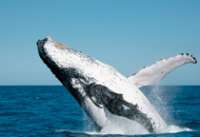
Requin Baleine

Lighthouse Bay

Beagle Bay

TIlba Tilba

Gipsy Point

Explorer la côte ouest
La partie Ouest de Cape Range National Park, où vous trouverez des plages, Ningaloo Reef, Yardie Gorge, Mandu Gorge et le centre des visiteurs Milyering, est accessible par une route goudronnée par le nord ou par une piste 4X4 depuis le sud. Il est facile d’explorer la côte ouest de Cape Range National Park. La frontière la plus au nord est à 36 km de la ville d’Exmouth. Au croisement de Yardie Creek, la route devient une piste pour les 4X4. Yardie Creek est à environ 1h de route d’Exmouth. De nombreuses plages et des sites de camping sont accessibles uniquement en 4x4.
Explorer la côte est
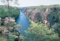
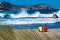
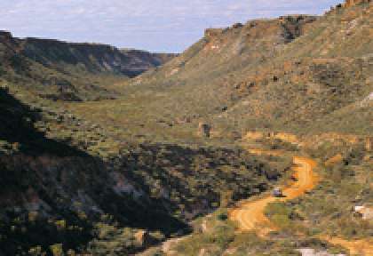
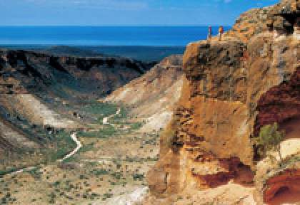
Les 2 canyons de Charles Knife Canyon et Shothole Canyon sont accessibles sur la côte est de Cape Range en quittant la route principale d’Exmouth le long de la côte du Golfe, la route d’Exmouth à Minilya. Cette piste offre les plus belles vues sur la parc national de Cape Range. Nombreuses opportunités de s’arrêter et de faire une promenade dans les canyons (soyez prudents) ou de juste admirer la vue. Une randonnée de 5km rejoint les deux canyons. Ça vaut le coup si vous supportez la chaleur. Vous n’avez pas besoin de payer l’entrée pour conduire sur la côte est du parc national de Cape Range.
Accès de Coral Bay
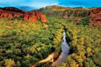
Depuis Coral Bay une piste 4x4 vous conduit jusqu’à Cape Range National Park en 3h30. La piste traverse les stations d’élevage de Cardabia et Ningaloo, et les terres militaires du Commonwealth avant d’atteindre la frontière la plus au sud de Cape Range National Park. Pour tous ceux qui possèdent un bon 4X4, c’est une aventure amusante à travers un environnement encore plus pittoresque et sauvage que le parc national de Cape Range. On y trouve aussi bien des plages désertes magnifiques avec des sites de plongée et de pêche, des lieux à visiter à Ningaloo Station incluant les ruines d’une ancienne station baleinière à Norwegian Bay et les ruines du phare de Point Cloates.
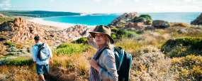
Nature sauvage et préservée
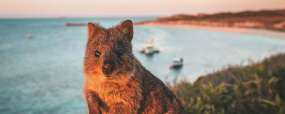
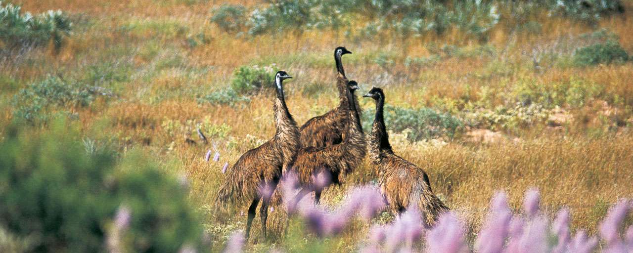
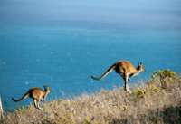
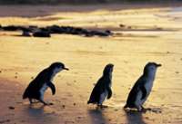
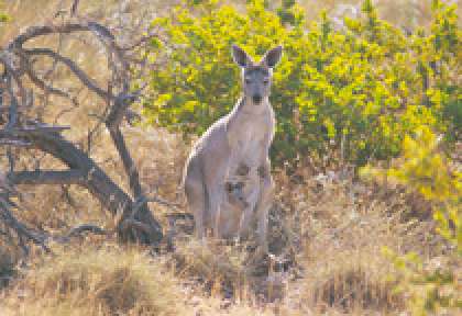
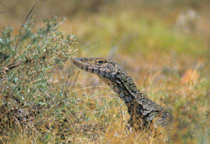
Autrefois le Cape Range été isolé, une île entourée pas les eaux, en raison de cet éloignement géographique certaines plantes et oiseaux sont aujourd’hui endémique à la région. Pas moins de 630 espèces de plantes à fleurs ont été recensée sur Cape Range. Cape Range est un parc national où la faune est importante. Vous découvrirez une grande variété d’oiseaux, d’émeus, de wallabys et de kangourous. Plus de 700 grottes ont été compté dans la région, et il est possible qui en reste beaucoup à découvrir.
Mangrove Bay
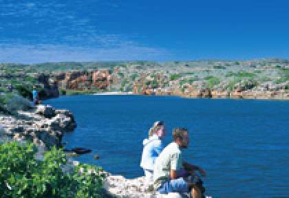
Mangrove Bay est située à 8 km au nord du centre Milyering, c’est le lieu idéal pour observer les oiseaux, notamment durant l’été, qui est la période de migration. Vous pourrez profiter d’une magnifique vue sur le lagon ainsi que de l’observation de petits poissons et autres animaux marins d’eau peu profonde. A environ 20 minutes de marche aller-retour, vous avez l’occasion d’observer les kangourous, galahs, émeus, cockatoos et le cacatoès corella, le meilleur moment pour les rencontrer sera au petit matin ou tard dans l’après midi.
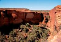
Randonnée Mandu Gorge
Mandu Gorge est situé à 15 km au sud du centre Milyering, c'est un sentier de randonnée. 3 km de marche au travers des gorges sèches, le sentier débute à la fin de la piste de Mandu Mandu et suit la crête Nord de la gorge, offrant de splendides vues panoramiques. Continuation en descendant dans le lit du ruisseau puis en suivant la base des gorges jusqu’au parking. Vous observerez ne nombreuses espèces d’oiseaux depuis le sentier. Comptez environ 2 heures aller retour. Le niveau de difficulté de randonnée est plutôt difficile car il peut faire plus de 50°C durant l’été, il y a très peu d’ombre, pas de toilettes à disposition ni d’eau potable.
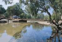
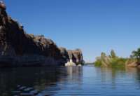
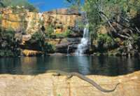
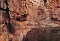
La gorge de Yardie Creek
Yardie Creek à 38 km au sud du centre Milyering, la route qui va d’Exmouth au Cape Range National Park se termine à Yardie Creek. Cette gorge de roche rouge s’est formée par l’érosion il y a des siècles. Exploration de cette gorge grâce à des randonnées pédestres ou des excursions en bateau. Cette promenade de 500 m aller retour vous entraine au-dessus des méandres rouges de la gorges avec vue sur Yardie Creek. La marche est de niveau facile, mais se complique un peu lors de la descente. Ajoutez à cela 1,5 km de marche, environ 1 h 30, et suivez le sentier de Yardie Creek jusqu’au bout, restez du côté nord de la gorge pour ne pas gêner les wallabies des rochers.
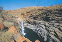
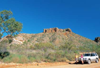
Shothole Canyon
Shothole Canyon est situé à 14km au sud d’Exmouth, une route mène au pied du canyon. Shothole canyon offre des vues à vous couper le souffle du parc national de Cape Range. Une route pittoresque autour du canyon vous permettra d’observer les couches de roches colorées. Grâce au sentier de randonnée au pied du canyon, explorez le parc national et observez les marsupiaux qui y habitent. Au début du printemps la région se couvre de fleurs sauvages. Au sud du parc, la route de Charles Knife Canyon offre des vues spectaculaires. Découvrez plus de 700 grottes éparpillées dans Cape Range.
Hébergements à Cape Range National Park
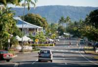
Exmouth est à seulement une heure de route depuis Yardie Creek, c’est le lieu le plus au sud où vous pouvez aller avec une simple voiture. Il est conseillé de séjourner à Exmouth pour faire des excursions à la plage et dans les gorges du Cape Range National Park. Les canyons de Charles Knife et de Shothole sur la côte est du parc sont faciles d’accès depuis Exmouth. Si vous préférez passer la nuit dans le parc national et être proche de la nature, il y a beaucoup de sites de camping, de nombreuses plages et autres lieux dans le parc.
Entrées aux parcs
Le centre des visiteurs du parc se situe à Milyering, à 52 km d’Exmouth. Vous trouverez ici de nombreuses informations sur la vie du parc. Les Rangers seront aussi à votre disposition pour vous orienter au mieux dans vos visites.
Le tarif d’entrée par véhicule est environ de $11et $5 par personne. L’entrée au parc s’achète dans les centres d’informations d’Exmouth ou de Milyering, ou à l’office des Rangers le long de la route principale du parc. Si vous visitez d’autres parcs nationaux du Western Australia, nous vous conseillons d’acheter un pass annuel des parcs nationaux. Si vous planifiez de camper dans les sites prévus à cet effet, des frais de camping seront en sus.
Que devez-vous emmener avec vous?
C’est important d’apporter de l’eau fraîche avec vous car il n’y a pas d’eau potable dans le parc. Le dernier lieu où vous pouvez en acheter est au supermarché de Lighthouse Caravan Park. C’est aussi le dernier endroit où vous prendre de l’essence et acheter de la nourriture.